Distance
and duration:
8
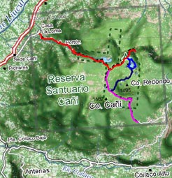
km one way, 3 - 4 hours uphill, 2-3 hours back. Starting point
is at 370 meters, maximum height 1.550 meters, total ascent
1.240 meters.
There are several detours you can combine, including circuits,
or going downhill to Coilaco. All possibilities are described
further in the text.
Physical
demand:
Moderate.
Orientation:
Easy,
there are signs at the access road. Inside the reservation,
the trail is marked with red arrows until an abandoned shelter
at Laguna Negra. However, there are no signs to the Mirador
(Viewpoint).
Best
time to do it:
November to May. It is possible to vist this reserve all year
round, in winter (july to September), it is very atractive
to do it on snow shoes. If there is a lot of snow, sometimes
it may be allowed to go just to Laguna Negra, but not to visit
the Mirador lookout.
Equipment:
Due to the steep trail we recommend trekking boots and hiking
poles. In dry season it is also possible with good sport shoes.
Entrance
fee:
The Fundación Lahuén, owner of the reservation,
charges an entrance fee of $ 4.000 |
From
the Headquarters’ office of Cañi you have to
cross the garden towards the hill until meeting with a dirt
road where you have to turn left. After 20 minutes of a soft
walk, we reach a bifurcation to the right with an indicative
arrow. Here starts a very rough path that climbs through the
hill slopes. It is much eroded, and closed curves are only
possible to overtake with a short jeep. At the end of the
first climbing there is a gate where sometimes there is an
entrance control or entrance charge to the reservation.
After 10 minutes walking we reach Casa La Loma, the last inhabited
place. The path continues climbing with many curves, in part
through forests that were once exploited, and in part through
steep prairies with cattle. While we are climbing, the view
opens towards Pucón. After walking for about 75 to
90 minutes from Cañi Headquarters, the faint path ends
at the shelter Aserradero, a rustic place where, previously
asking the administration, it is possible to stay overnight.
It is important to take sufficient water from the fountain,
since there is no reliable water ahead.
The shelter marks the entrance to the reservation, and shortly
after we enter the path, the vegetation gets thicker and soon
we find ourselves in a beautiful forest with mañíos
and giant coigües. With luck you can hear and even see
the Magellan woodpecker: the male has an impressive red head
and the female is completely black. To the left of the path
you hear a river running, but it is seldom visible. About
15 minutes after the shelter, the steep climbing ends and
we reach a plateau at a height range between 1.250 and 1.350
m. It has an area of 2 x 3 kms and it is surrounded by hills.
Here there are scattered about a dozen of small lagoons.
After walking for 30 to 40 minutes from the shelter we arrive
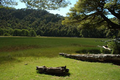
at Laguna Seca (Dry Lagoon). Different from its name, it is
actually the biggest water place in the whole reservation.
Its shores have a lot of cattail, which is the perfect habitat
for a number of birds. The araucarias, that we have seen isolated
previously, grow now to their fullest.
The path continues to the right, along the lagoon. Red arrows
nailed to the trunks and fences show the route, in case of
any doubts. 20 minutes later, after a short ascent, the path
gets to a wider trail: an old timber road. Continuing through
the right, it is possible to arrive after 2-2½ hours
to Coilaco (later described as “Bajada a Coilaco”).
To continue towards the Mirador (Viewpoint) you have to take
the path to the left, in direction northeast. In 15 minutes,
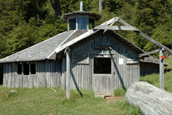
after passing by another small lagoon, we reach the old shelter
“Laguna Negra”, which nowadays is barely a couple
of planks.
Unfortunately, there is no sign here. There is a path that
continues in the middle between the two lagoons, which marks
the beginning of the circuit “Lagunas del Cañi”,
described further on the text.
To continue towards the Mirador you must take one of the paths
that go toward the hills behind the shelter, soon all of them
get together in one. This is the hardest part. It climbs in
zigzag through the rough slopes of the hill, and there are
very steep parts. In 20 to 30 minutes we should be able to
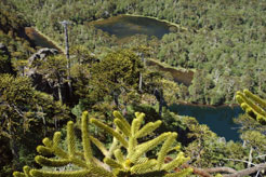
overtake the last 220 meters of the ascent. The top is formed
by large rocks that fall almost vertically to the lagoons
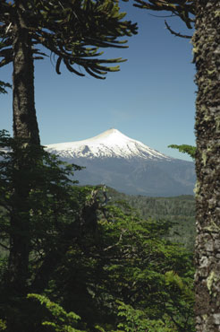
to our feet. The view to the south is spectacular, with the
volcanoes Lanín, Quetrupillán and Villarrica
at the bottom.
Lagunas
del Cañi:
It is a small circuit about 2 kilometers long that you can
easily walk in 30 to 40 minutes and that you shouldn’t
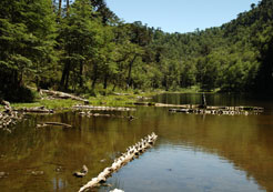
miss. It goes around all the lagoons that you see from the
Mirador. It is an old self-guided trail, now a little abandoned,
but there are still some signs.
The trail begins at the half destroyed shelter of Laguna Negra.
Going between the two lagoons ahead, you will reach in 100
meters a sign “Lagunas del Cañi”. Then
the trail turns to the left and continues along the largest
lagoon. Continuing to the south you see first a small lagoon
to the right and then a bigger and narrower one to the left.
Almost at the end of the later you must turn in a fork to
the right, and soon you will get to another lagoon, this time
a square one, that you follow to the left. Once you reach
its south side there are two options: Near a tree with a wooden
sign nº 6 nailed to it you can continue along the lagoon
towards northwest, or get away from it taking the route southwest.
Barely 100 meters ahead there is a bifurcation to the right
that goes northeast. Near this bifurcation there is a tree
with a mark nº 7. This path leads to another tiny lagoon
(nº 8) and then comes together with the other path that
goes along the square lagoon (near nº 9). From this point
there are about 500 meters to get back to the start of the
circuit.
If near point nº 7 you choose to take the path that continues
to the south and then southwest, you are in the trail to Las
Mellizas, which we describe further in the text.
Getting
down to Coilaco:
There is the option to get down through an ancient timber
trail towards the valley of Coilaco. From the crossing with
the trail that comes from Pichares there are 3,4 kilometers
until you reach a road for all-wheel-drive vehicles, and from
this point there are another 5,9 kilometers to get to the
gravel road that continues along the valley. The scenery is
not very attractive, its biggest advantage is that you don’t
have to use the same trail you first took. Taking it the other
way round, it allows you to get with a 4WD vehicle to a height
of 1.150 meters and reach the area of the lagoons without
the strong ascent you must do if coming from Pichares.
From
the crossing with the trail Mirador, the path goes first to
the southwest and then makes a big semicircle around the base
of the Cerro Redondo finalizing in direction east. After 45
minutes walking we reach a closed curve to the right, the
path gets back to the south and takes a steep descent. Since
here there are a number of fallen trees, it is not possible
to continue by car, not even a jeep. Ten minutes later a fence
and a sign indicate that we are leaving the reservation El
Cañi, and after another 10 minutes we reach a timber
road in use. You must take the left.
Continuing through the timber road you will reach in 20 minutes
a flatter area with several houses, some abandoned, and others
in use during the summer. There is river that runs through
the bottom of the valley. When you reach a T crossing, you
must take the road to the right that follows uphill to the
Valley of Coilaco to get together in 45 minutes with the main
road.
Las
Mellizas Trail:
It is an alternative trail to get back from the circuit Lagunas
del Cañi to the Laguna Seca. There are about 3,2 kilometers
and 50 to 60 minutes walk. It is not often used, and therefore
it is not very clear, but with some experience in orientation
it is still relatively easy to follow.
From point n° 6 of the circuit “Lagunas del Cañi”,
the south end of the square lagoon, you have to take a trail
that continues to the south. Shortly afterwards you have to
ignore another path to the right that goes back to n°7.
Some minutes later there is another path that visits a small
lagoon, the correct path continues in direction south-southwest
and gets uphill to a small pass that you reach after 15 minutes.
A little further ahead there is a path to the left to the
small lagoons Las Mellizas. The path gets downhill to reach
10 minutes later another lagoon without name and immediately
afterwards there is the trail that goes to Coilaco, previously
described in the text. Here you have to turn right and in
15 minutes you will reach the main trail from Pichares. |


