1st
part: Chinay – Laguna Azul (“Los Venados”
Trail):
Distance
and duration:
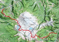
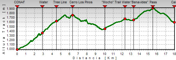
There are 18,1 kilometers with a total ascent of 1.450 meters.
Carrying a backpack it takes about 6-8 hours.
Altitudes:
Conaf’s Rangers’ Office Quetrupillán: 980
m
Cerro Los Pinos: 1.740 m
Junction with Mocho trail: 1.440 m
Pass: 1.920 m
Laguna Azul: 1.590 m
The beginning of the trail is well marked, and starts about
50 meters before reaching the CONAF’s rangers’
office. Through a catwalk you must cross the Chinay River
and then we get closer to the mountains on the other side.
After 30 minutes the trail starts to climb a mountain slope
with continue zigzags. Take it easy, the climb is very long,
and there are about 700 meters to gain. The forest is mixed,
with raulíes, coigües, colihues and many notros
which in springtime bloom fire-red. 15 minutes later the first
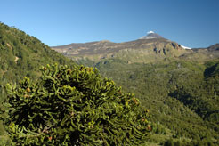
araucarias appear. Soon you will have the first views towards
the valley of Palguín Alto, and the Villarrica volcano
with the Pichillancahue valley on the other side. Farther
ahead you will find a sign that indicates that there is water
20 meters downhill; even though the access is not easy, it
is better to get some here, since the next chance to find
clear water again is several hours ahead.
After 1½ to 2 hours walking you will reach the limit
of the forest. There is still some coirón, the typical
highland grass, but it becomes scarce. Now the land gets more
desert-like and you will find a rather thin thread of water,
but it is not safe. Soon the trail turns into a pass, but
instead of getting downhill, you have to turn right and keep
on climbing; some stones in a pile will confirm that you are
on the right track. At this point there are usually strong
winds that make it hard to walk, especially if the “Puelche”
is blowing, a very strong wind that comes against you from
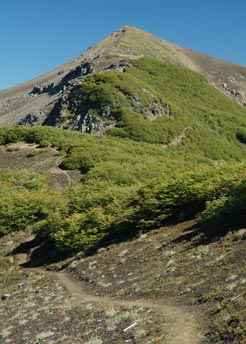
Argentina. The trail continues along the left side of the
summit of Cerro Los Pinos, and then along the edge of the
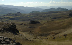
Mocho Range, going up and down all the time. There are some
rocky parts that take turns with areas of stubby lengas. The
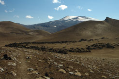
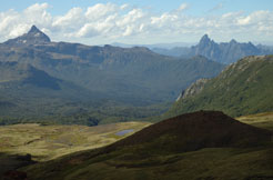
views are great: Towards the north there are the volcanoes
Llaima, Tolhuaca and Lonquimay, in front there is the Quetrupillán
volcano, and farther, the impressive Lanín.
To the left you can see the valley of the Mocho River, much
devastated by forest fires. Here there is an alternative entrance
to the estate “Paraíso Escondido”, which
avoids the steep climb to the Mocho Range and shortens the
first part in a couple hours, but does not have the views
and sensations of the original trail.
About half an hour after having reached the highest point
next to Cero Los Pinos, the trail gets downhill and enters
into a thick forest. Finally it gets to the bifurcation where
it meets with the Mocho Trail. From the Conaf’s rangers’
office to this point there is an about 3 to 4 hour-walk.
From this union, the trail starts to gently climb and reaches
the limit of the forest in half an hour. Here you have to
cross some outlets of the Mocho River, but in the dry season
they are practically empty. In some travel guides they recommend
to camp here, but we don’t think it is a good place
to do it. However, if you want to do the ascent of the Quetrupillán
as a part of the Villarrica Traverse, this is the area where
you get the closest to start it.
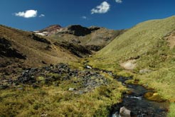
After leaving the forest behind, it begins a long part with
a gentle climb along the slopes of the Quetrupillán,
making a wide turn to the south. To the right there is a bizarre
rocky peak– the remains of an ancient volcano. After
about 20 minutes we cross a crystal-clear creek, and 15 minutes
later we arrive to a meeting of another two, which actually
originate the River Llancahue that runs all the way down to
Coñaripe. Immediately afterwards there is a bifurcation:
if you continue straight ahead there is the "Colonia
Benavides" Trail which connects with the gravel road
Palguín – Coñaripe near the Hot Springs
El Rincón. It could be used as an “emergency
exit” if you don’t want to continue in case of
bad weather. Next to the bifurcation there is a plain ground
where you can pitch a tent if it is not too windy.
The main trail here turns to the southeast and starts climbing
again. With good visibility you can see from afar the route
between the mountains and the pass we will have to reach.
After another hour walking and an exhausting climbing, you
will notice a depression between two mountains, but it is
still not possible to see the Laguna Azul there. The trail
gets away and climbs a bit more; here we reach the highest
point of the whole trail. Now there is a long way downhill
to get to the goal. While going downhill you can notice several
volcanic craters and the lava flow that formed the plug that
originated the Laguna Azul (some maps call it Laguna Los Patos).
After another hour, at the end going in zigzag, we reach the
shore, next to the outlet. In a small lenga forest there is
enough space to pitch a tent. If there are too many people
and the best places are gone, you can cross the outlet and
walk through a path for about 5 to 10 minutes until it gets
downhill and approaches to another river. Through this route
it is possible to get down all the way to the Liquiñe
valley, few kilometers ahead it turns into a wide road for
four-wheel-drive vehicles. Several Chileans use this road
when they come to fish or make a picnic at the Laguna Azul.
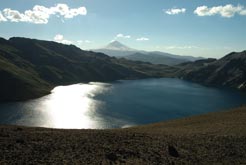
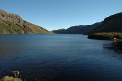
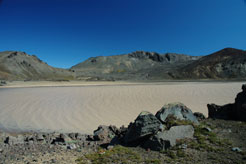
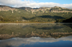
This lagoon, with its deep blue waters, narrowed between desert-like
mountains, is an overwhelming experience. Unfortunately its
surroundings have been seriously deteriorated in the past
years. The small forest is almost completely littered by all
kind of garbage, and visitors without ecological conscience
cut the twigs to make fire.
2nd
part: Laguna Azul – Laguna Avutardas (“Las Avutardas”
Trail ):
Distance
y duration:
Including the detour to Laguna Blanca there are 16,9 kilometers
with a total ascent of 520 meters. Carrying a backpack it
will take you 5 to 6½ hours.
Altutudes:
Laguna Azul: 1.590 m
First pass: 1.720 m
Laguna Blanca: 1.640 m
Second pass: 1.830 m
Laguna Avutarda: 1.450 m

Continue the march between the mountain you used to arrive
here and the lava flow that plugged the lagoon. Few minutes
later the trail crosses a much eroded lava field, formed by
big volcanic rock chunks. After a short climbing you have
to cross another arm of the same lava tongue. To the left,
at the slopes of the Quetrupillán, you can see the
crater partially open from where the eruption came.
40 to 50 minutes later we reach a pass, and a wide volcanic
dump area appears ahead of us. However, the trail turns to
the southeast getting gently downhill towards a wide ditch.
Through the middle of it runs a thin river. Even though its
waters carry a lot of sediments, they still could be OK for
drinking if you let them set for a while. Each time the river
grows, there is a chance that the trail gets erased, but a
line of stakes indicate the route at the bottom of the ditch
towards the west side where you can see a small climbing towards
another pass. From the top it is possible to see the Laguna
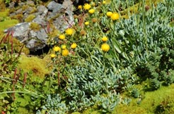
Blanca. Getting down there is a small spring that manages
to create a green spot with surprising plants amidst the dryness
around.
The Villarrica Traverse passes half kilometer away of Laguna
Blanca. There is no sign, but you can notice a path that leads
there. It is a well-worth detour. The milky colors of its
waters, along with the dark rocky formations on the shores,
create a unique landscape. On the top you can see the south
side of the Quetrupillán, covered with wide glaciers,
meanwhile its west side has not always snow. It is possible
to camp at Laguna Blanca. It is not the best place though,
but people who want to make the whole excursion in only tow
days, can stay overnight here.
From Laguna Blanca the trail continues to the south, going
along the dry riverbed of a long ravine. To the right there
is a volcanic cone with a deep red color. All the ground is
covered with sediments of previous eruptions. In the neighboring
mountains there are stripes of rocks, remains of ancient volcanic
calderas. After half an hour we turn to the east and start
to climb the slope, passing along the right side of a tongue
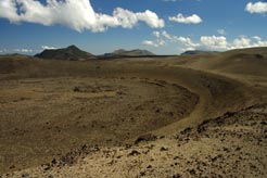
of solid lava. Once on the top, you will realize that you
have climbed the edge of a big crater. At the back you can
see the Quetrupillán and, for the last time, Laguna
Blanca. In this part another trail comes together, the one
that comes from Rinconada, but it is seldom used and not very
well marked.
We continue walking still very high through the slopes of
a mountain range heading south-southwest. From here you can
see the upper valleys of Liquiñe, covered with thick
forests, and the volcano Mocho-Choshuenco at the back. Then
the trail turns east and we enter into Argentinean territory
for about 2 kilometers (be aware that some maps don’t
show this part of the trail correctly). In this area you will
gently go downhill and cross two crystal-clear brooks, the
best water you will find on the second day, then you will
have to climb on the other side to get to the next pass and
enter Chile again. At this point, a fantastic landscape opens
before your eyes, with the Lanín volcano and the Peinetas
mountains, the Quinquilil and all the valley of River Puesco.
To our feet there is a wide plain ground covered with grass
and some stuck-watered ponds. The trail continues along the
left side to the north, approaching a cliff. Through big loose
rocks you get downhill to another marsh-like plain ground
you have to cross towards southeast. Stubby lenga forests
grow isolated in the driest zones. We cross several brooks
that serve as outlets to the plain grounds and originate the
River Puesco. Then the trail continues through a rough hill
that separates two valleys. From here it is possible to see
the Avutarda Lagoon in the background. Soon afterwards we
enter the forest and it gets easier to continue downhill.
Half an hour later the trail gets out of the forest and crosses
another marsh area that goes all the way to the shores of
the lagoon. To complete this second part of the trail you
have to go again into the forest and continue along all the
north shore of the lagoon. Through the foliage you can distinguish
a sandy beach on the east side. To get there you have to take
the trail to a clearing covered with grass, where remains
of old fires indicate the camping area. Through the bushes
you can get to the lagoon, and take some water. Unfortunately,
this area has also a lot of garbage.
The Avutardas Lagoon (in some maps it is also called “Laguna
los Patos”) is surrounded by mountains on three of its
sides. It has a lot of vegetation on its shores, save the
part with marsh where the outlet is. Its name is a local voice
for two families of geese –Caiquén and Canquén-
which usually nest in this marsh.
3rd
part: Laguna Avutarda – Puesco:
Distance
y duration:
To the end of the trail in the Camino Internacional there
are 8,4 kilometers with a total ascent of 170 meters and 660
meters downhill in all. Carrying a backpack it takes about
2½ to 3 hours.
To the CONAF’s rangers’ office in Puesco there
are another 3,4 kilometers with a total descent of 370 meters,
and about 1 hour-walk .
Altitudes:
Laguna Avutarda: 1.450 m
Highest point: 1.480 m
Meeting with the Camino Internacional: 1.000 m
CONAF’s rangers’ office at Puesco: 730 m

From the clearing at the Avutarda Lagoon the trail gets into
the forest, now dominated by lengas, which are no more bushes,
but impressive trees. Soon coigües, canelillos and quila
join the vegetation, among other species. About 20 minutes
after the start of the march, the trail crosses a crystal-clear
brook, with better water than even the lagoon. After a small
climbing we reach a marsh plain ground. First the trail goes
along its left side, then crosses through it and gets again
into the forest on the other side of the valley. Now it appears
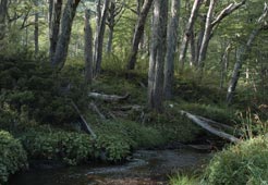
a plain area with a lovely forest. Very noticeable are vast
spots with alstromerias and a great number of ancient fallen
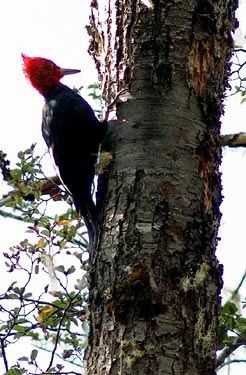
trees. In this area there are usually woodpeckers, which you
can hear hammering from afar.
After another short climbing we reach a clearing on the slopes
of a hill and you can see the bottom of the valley of River
Puesco, where you will have to get to. The descent is quick
and steep; parts with forest take turns with grass covered
clearings. Remains of old gates show that these lands used
to be worked. Half an hour later, in a ñirres zone,
the trail comes together with a road for four-wheel-drive
vehicles. There is a big sign that indicates that here starts
the trail to the Quilquilil volcano, commonly known as the
Colmillo del Diablo (Devil’s Fang). The Villarrica Traverse,
however, continues to the east through the trail, keeping
an altitude between the 1.000 and 1.050 meters for about 40
minutes before reaching the Camino Internacional that leads
to the International Pass Mamuil Malal or Tromen.
Here you can try to hitchhike or you can walk 3,4 kilometers
to Puesco, where is the CONAF’s rangers’ office.
At the back of the house, next to the river, it is possible
to camp if you have to wait for the buses that run through
this area early the next morning.
If your goal is to make the Villarrica Traverse all the way
through, you have to take the Camino Internacional towards
south to the bridge Momolluco, for about 2,2 kilometers. Here
is the starting point of the “Momolluco” Trail,
which along its continuation the “Lagos Andinos”
Trail will provide you two extra days of adventure.
|


