|

|
| “Mirador
Los Cráteres” Trail – Villarrica National
Park |
|
Leider
hatten wir bisher noch nicht Gelegenheit, diese Seite ins
Deutsche zu übersetzen. Bei eventuellen Fragen können
Sie sich aber an uns wenden. |
| |
| This
is not a well-known trail, despite how close to Pucón
it actually is. Its biggest attraction is the magnificent view
to the volcano and lake, and a number of bizarre small craters
inside a lava field. |
|
 |
| General
Information: |
| |
Distance
and duration:
4
km one way, 1½ hours uphill, 1 hour back. Starting
point at 1.175 meters, maximum height 1.430 meters, total
ascent 280 meters.
Physical
demand:
Soft,
easy excursion for the whole family.
Orientation:
Easy,
the path is marked with iron stakes painted in green, plus
additional signs. Only in the last part, the lava field, you
must pay more attention.
Best
time to do it:
December to May. It is a very atractive area for hiking with
snow shoes in winter, although it is not possible to walk
along the trail. Better just hike through the ravine (see
options).
Equipment:
For
the main trail described bellow, it is enough to wear good
sneakers. If you want to try the other possibilities, it is
better to choose trekking boots and hiking poles.
Entrance
fee:
Tickets must be bought before at www.pasesparques.cl and shown at the CONAF
ranger station. |
|
 |
| How
to get there: |
From
Pucón, take the road towards Villarrica until the crossing
“Al Volcán” on km 1. The road is paved
for the first eight kilometers until the entrance to the National
Park with the CONAF control at km 9. Shortly afterwards, you
must take the road to the left with the sign “Cuevas
Volcánicas”. The rough gravel road continues
through a slag dump and forest for another 4 kms until you
get to the parking lot about 300 meters further than the entrance
to the private owned Cuevas Volcánicas (Volcanic Caves).
It is a rocky and tough road but, driving carefully, it shouldn’t
be a problem for a regular car (only if it is really low). |
| |
 |
| Route
description: |
The
trail begins at the CONAF parking lot about 300 meters after
the area of the Volcanic Caves. There is an informative panel.
First you go through ancient volcanic slag dumps, mostly covered
by local vegetation of coirón and moss. There are isolated
groups of lengas. After about 20 minutes you must cross a
wide and dry river. To the left there is the edge with the
Volcanic Caves. Immediately after that, the trail enters a
thick coigüe forest and starts to climb. Then it gets
further into the forest and crosses several small creeks with
a lot of vegetation, but usually dry. After about 45 minutes
walking, you get to a deeper creek. In summer, this small
river has the only water you will find during the whole excursion.
The trail continues with a gentle climb, the forest gets lower,
with mostly lengas. After one hour since the begin of the
excursion you will get a small hill with a sign “Mirador”,
from this point you have a beautiful view towards the Villarrica
Volcano and the valleys Zanjón Seco and Correntoso.
At the back you will see the lakes Caburga and Huilipilún,
the Llaima Volcano and the Nevados de Sollipulli.
Now the trail descends towards the volcano. The lenga forest
takes turns with Andean prairies. Soon you will find the first
signals of lava from a recent eruption. Now it is more difficult
to see the trail, which follows the lava flows uphill. Where
there are no green stakes, you can use for orientation some
branches that are set in the lava.
After one and half hour you will get to the goal: a file of
craters about 5 to 10 meters wide, from where the lava flowed
to both sides. Some craters are in very bad shape, but others
are very easy to recognize. The lava formed interesting folds
and it is getting cracked by invasive vegetation. In some
parts it gave away, originating low, but several meters deep
caverns.
Options:
The
craters are at the side of a deep dry creek. There is no trail,
but it is possible to get down to the bottom of the creek
and follow downriver until get to the path on the way up,
at the Volcanic Caves, which roofs you will see many times
during the excursion. The hike is not too easy, but it is
shorter and faster than using the same way back.
Another option is to follow the craters towards the east over
the limit of the forest, until finding another dry river to
follow and get out through the valley of the Correntoso River.
This excursion must be made only if going with a group, and
you must consider about 5 hours walking until getting to the
Camino Internacional, if you don’t have the luck of
having a car to bring you back. |
|
 |
| Logistische
Unterstützung: |
Guide:
Sie können für diese Wanderung einen Deutsch sprechenden
Führer für Ch$ 50.000 (US$ 70) anmieten.
Transport:
Wenn Sie ohne Farzeug unterwegs sind, können wir Ihnen
Transport zum Startpunkt vermitteln (bitte mindestens einen
Tag im voraus bestellen). Dies sind die möglichen Alternativen,
Preise pro Gruppe bis zu 4 Personen:
| Transport
zum Wanderbeginn: |
Ch$
30.000 |
| Hin-
und Rücktransport mit 3 Stunden Wartezeit: |
Ch$
50.000 |
| Transfers
und Wanderung mit Deutsch sprechendem Führer |
Ch$
75.000 |
|
Preise
für Gruppen über 4 Personen auf Anfrage.
Wichtig: Mögliche Eintrittsgebühren
sind nicht inbegriffen.
GPS Miete:
Wir können Ihnen einen GPS-Empfänger Garmin eTrex
mit den für diese Wanderung nötigen Tracks und Waypoints
vermieten.
Für nähere Informationen > 
|
|
|
|
Click
here
to see enlarged images
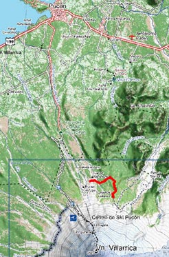
Area map
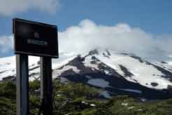
View towardsVillarrica volcano from the first lookout

Calabozo hills and Lake Caburgua
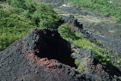
Row of small volcanic cones
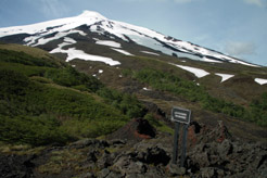
The craters and Villarrica volcano
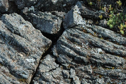
Old lava flows
|


