|

|
| “Pichillancahue”
Trail – Villarrica National Park |
|
Leider
hatten wir bisher noch nicht Gelegenheit, diese Seite ins
Deutsche zu übersetzen. Bei eventuellen Fragen können
Sie sich aber an uns wenden. |
| |
It
is an interesting walk to the most accessible glacier of the
Villarrica Volcano. It does no correspond to the typical image
of a glacier, since it is covered with volcanic ashes. The trail
starts in a beautiful araucaria forest and offers impressive
views to five volcanoes. |
 |
| General
Information: |
| |
Distance
and duration:
3,7 km one way, 75 – 90 minutes uphill, 60 minutes back.
Staring point at 1.290 m, highest point to (in front of the
glacier) 1.710 m, total ascent 420 m.
If you must start at the rangers’ office, you will have
to walk 4 extra kms in both ways, and add 90 minutes uphill
and 60 back.
Physical
demand:
Low; moderate if you start from the rangers’ office.
Orientation:
Easy,
the path is marked with iron stakes painted in red.
Best
time to do it:
December to May.
Equipment:
Best
are trekking shoes. It is also possible with firm sport shoes.
Entrance
fee:
Tickets must be bought before at www.pasesparques.cl and shown at the CONAF
ranger station. |
|
 |
| How
to get there: |
Getting
out of Pucón take the paved road to Argentina (Camino
Internacional) until the crossing Palguín (km 20),
turn to the south and keep on driving to the Hot Springs of
Palguín through a good gravel road. Instead of entering
to the hot springs (km 30) take the road to the left with
the sign “Coñaripe”. At km 35 there is
a gate that welcomes you to the National Park and the road
gets worse. This area is known as “Chinay”. A
little bit ahead there is the CONAF’s office (km 36)
where they charge the entrance fee and you can ask about the
conditions of the rest of the road. From here on four-wheel-drive
is a must. First there is a part full with roots and large
rocks, and then it comes the final ascent to the pass. Farther
ahead there is a parking place with the beginning of the trail.
There are 40 kilometers from Pucón, but due to the
poor state of the road it takes 1½ hours. Until the
rangers’ office there are 36 kilometers, approximately
an hour. |
| |
 |
| Route
description: |
The
path starts slowly uphill through a splendid araucaria forest
mixed first with coigües and then with lengas, but after
20 minutes walking we reach the limit of the forest. There
is a spectacular view in 360º to the volcanoes Villarrica
to the west, Llaima and Sollipulli to the north, Quetrupillán
and Lanín to the east and Choshuenco/Mocho to the south.
Shortly afterwards there is a fork with a sign to the right
“Los Nevados”, meanwhile the path to the glacier
Pichillancahue continues straight ahead, over a small hill
covered in high land grass, which separates two brooks that
run parallel at least 50 meters from each other. To the left
is the Pichillancahue, which results from the melting waters
of the glacier and brings lots of dirty water mixed with volcanic
ashes; later downhill it comes together with the river Llancahue
and flows towards the lake Calafquén. To the right
there is a brook with clear waters that runs towards Chinay
and Palguín, the same road we came from.
40 minutes after we started to walk, the valley of the Pichillancahue
deviates to the left, and the soil gets almost barren. The
strange rocky formations that enclose the valley are rests
of an ancient volcanic caldron of the Villarrica. Some parts
of the path are not very clear, but you just have to continue
through the valley towards the Villarrica volcano. At the
bottom you can distinguish a dark mass, very cracked, that
closes the valley. When we get closer, it turns out to be
the glacier, which is completely covered by volcanic ashes,
since it is just on the direction that the winds blow from
the crater. Removing this cape of ashes on its sides, it is
easy to see the ice mass beneath. It is possible continue
uphill for another 40 minutes to reach another hill to the
south, from where there is an impressive general panorama.
|
|
 |
| Logistische
Unterstützung: |
Guide:
Sie können für diese Wanderung einen Deutsch sprechenden
Führer für Ch$ 80.000 (US$ 100) anmieten.
Transport:
Wenn Sie ohne Farzeug unterwegs sind, können wir Ihnen
Transport zum Startpunkt vermitteln (bitte mindestens einen
Tag im voraus bestellen). Dies sind die möglichen Alternativen,
Preise pro Gruppe bis zu 4 Personen:
| Transport
zum Nationalparks-Eingang: |
Ch$
55.000 |
| Hinbringen
und Abholen (am selben Tag): |
Ch$
85.000 |
| Transfers
und Wanderung mit Deutsch sprechendem Führer |
Ch$
120.000 |
|
Preise
für Gruppen über 4 Personen auf Anfrage.
Wichtig: Mögliche Eintrittsgebühren
sind nicht inbegriffen.
GPS Miete:
Wir können Ihnen einen GPS-Empfänger Garmin eTrex
mit den für diese Wanderung nötigen Tracks und Waypoints
vermieten.
Für nähere Informationen > 
|
|
|
|
Click
here
to see enlarged images

Area map
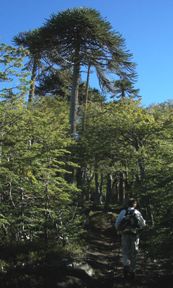
At the beginning, the path crosses a lush forrest
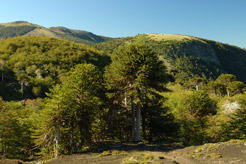
After 20 minutes we reach the tree line
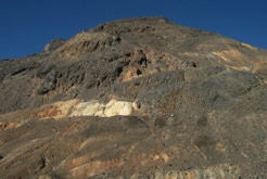
Multicoloured walls of an ancient volcanic caldera
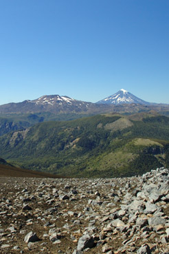
View to the neighbouring volcanoes Quetrupillán and Lanín
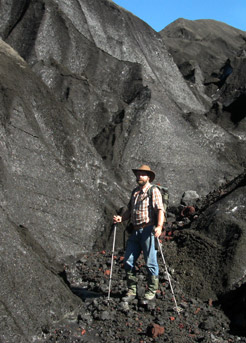
The ice of the glacier, grey coloured by the volcanic ashes
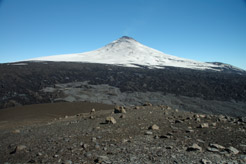
Villarrica volcano with Pichillancahue glacier
|


