|
|
Villarrica-Traverse,
First Part: Ski Center to Chinay
“Challupén - Chinay” Trail –
Villarrica National Park |
|
| It
is the first part of the famous trekking known as the “Villarrica
Traverse”, which goes through all the name’s sakes
National Park, from the Villarrica volcano until Puesco, almost
at the border with Argentina. This part goes around the active
volcano through its west and south sides, and offers spectacular
views to its glaciers and lakes to its feet. Most of the time
the hike goes over the limit of the forest, the path crosses
ancient areas of volcanic slides, but there are also lush lenga
and araucaria forests. |
|
 |
| General
Information: |
| |
Distance
and duration:
From the Ski Center until the end of the path in the public
road Coñaripe – Palguín there are 29 kms
with 905 m total ascent. With light luggage it is possible
to do it in one day (9 to 11 hour-hike) if you have organized
the transport to take you back. More common is to do it in
two days camping half way, or taking it as the first part
of the Villarrica Traverse, which takes between five to six
days. With the proper luggage you must calculate with two
days of 5 to 7 hours walks.
Altitudes:
Trail head at Ski Center:
1.400 m
Highest point (after Zanjón Molco): 1.570 m
Zanjón Pino Huacho: 1.205 m
Pass between Zanjón Coñaripe and Estero Tralco:
1.520 m
Lowest point (crossing Río Pichillancahue): 1.125 m
Trail end: 1.155 m
Physical
demand:
Moderate,
if you want to do it as a two-day-hike.
High, if you do it in one day, or if you have to carry the
equipment for the "Villarrica Traverse", that lasts
5 to 6 days.
Orientation:
Easy.
The path is well marked with iron stakes numbered from 1 to
84, painted in yellow. There are some stakes missing in exposed
areas, and in the volcanic dump on the south it is impossible
to read the numbers due to the erosion. There are also many
wooden signs, but the shown kilometers aren’t correct.
In barren areas the route is marked with files or piles of
rocks (cairns).
Best
time to do it:
January to April. The national park authorities Conaf don't
allow to do this hike with snow and close the trail in the
end of may until mid-November. After a rough winter, it may
be re-opened only in December.
Equipment:
It
is essential to wear good trekking shoes; walking canes are
a great support to cross the dump area and the descents. Since
75% of the trail is over the limit of the forest, it is very
important to have good sun protection (hat and sun block).
It is also very important to carry a good amount of water.
Entrance
fee:
Tickets must be bought before at www.pasesparques.cl and shown at the CONAF
ranger station. |
|
|
 |
| How
to get there: |
The
starting point is the Ski Center. From Pucón take the
road towards Villarrica until a good marked crossing on km
1. The road to the volcano is paved for the first eight kilometers
untill the entrance to the National Park with the CONAF’s
control on km 9. Here starts a rough gravel road. Soon afterwards
you must turn right and the road begins to ascent in wide,
zigzag curves. At km 15 you will reach the first ski lift
called “Juncalillo”, and finally, leaving the
forest behind, the road ends at the Ski Center’s parking
lot (km 17).
From Pucón it is an about 30 minute-ride, with no public
transportation, but it is possible to hitchhike. |
| |
 |
| Route
description: |
The
trail Challupén – Chinay starts in the last curve
200 meters before the Ski Center. There is a big informative
sign with a map. Here we are above the limit of the forest,
and the landscape is very sterile, but there are still some
spectacular views towards the smoking volcano. After 10 minutes
we cross a wide ravine, “Zanjón Correntoso”.
The cracked lava, almost black, belong to the last eruption
of the Villarrica in 1984. Twenty minutes later we get to
the “Zanjón Molco”, a ravine which goes
all the way down to the lake, half road between Pucón
and Villarrica. Then the path begins to slowly climb until
getting to the mark of the 1.550 m.a.s.l, which we will keep
during the next half hour. This area of lava, barren dumps
is the highest of the trail.

Finally we get into an area with a characteristic high land
grass and the trail descents towards a small lenga forest,
which we reach 30 minutes later. Due to the high land climate
and the rocky soil, the lenga grows small. Soon afterward
the trail gets down to a deeper ravine, “Zanjón
Voipir”. Normally it brings melted water, which comes
from an impressive hanging glacier, but for the amount of
ashes it has, the water is muddy and not good for drinking.
Leaving the Zanjón Voipir behind, the trail enters
again the forest, which turns thicker the more we go into
it. The first araucarias appear, still small, and later they
give place to huge and ancient specimens. After the rocky
first part of the road, it is nice to walk again over soil
and hear the sounds of the forest.
Shortly afterwards there is a fork with a wooden sign that
announces “A Villarrica”. The trail Challupén
continues to the left and soon descents to another big ravine,
the “Zanjón Pino Huacho”. An arrow indicates
“Agua 30 mts” to the right, where in the rocky
wall of the canyon appears a water spring. It is the only
possibility to find safe water in the first leg of the trail.
There is enough room to pitch a tent if needed be.
The path continues steep uphill to get out of the ravine and
enters the forest again. You can see several alternative paths
in this area, but they are less marked than the main one.
The people of nearby towns come here in the fall to collect
piñones, the fruit of the araucaria tree. About 30
minutes after leaving Pino Huacho behind we arrive to another
fork with a sign to Lican Ray. Immediately after that we arrive
to Zanjón Challupén, wider than the previous
ones. The eruption of 1971 came through it with a slide of
mud, stones and melted snow that went all the way down to
the lake Calafquén.
The trail gets down to the bottom of the ravine and crosses
it in diagonal uphill. The way out is not easy to find, you
must continue through the dry river bed for another 500 meters
until you see on the south side some darker lava rocks where
the next stake (Nº 38) is. The path continues for another
400 meters towards the volcano and then turns 180 grades and
keeps on climbing the wall to get into the forest again. Shortly
ahead there are the “Laguitos de Challupén”,
two small ponds of 10 to 15 meters diameter. It is stuck water
without a clear inlet, not recommended for drinking. It is
a good place for a picnic and in case of an emergency it is
also possible to pitch a tent.
The path continues slowly uphill through a lush forest to
cross 30 minutes later a small valley with a brook. On its
south shore there are plain places to pitch tents, although
there is no shadow. If there is water running in the brook,
this is the best option for a camp site, if not, you have
to continue for 15 minutes. From the Ski Center there are
in all about 4 to 6 hours walk.

The trail continues for another 15 minutes through the forest
until arriving to the Estero Ñilfe, pointed out with
a wooden sign. Now the view to the south is clear and it is
possible to see the double volcano Choshuenco/Mocho. Some
trekking guides recommend this place to pitch a tent, but
it seems that there is only water in the afternoon, when the
snow melts. After the Estero Ñilfe begins the “Valle
del Fuego” (Valley of the Fire), a wide area of recent
volcanic activity. Impressive are the fields of “corded
lava” which acquired this strange look due to the flatness
of the terrain and the density of the magma when it cooled
out. The creases look like roots or twisted strings. In the
volcanic dumps it is not easy to recognize the path, in certain
areas you must be aware of rocks that are put one on top of
another, that are considered marks that show the route.
The trail continues softly uphill until reaching 45 to 60
minutes after the Estero Ñilfe a pass between a secondary
crater of the Villarrica and smaller hills to the south. From
here there is a first view towards the Lanín volcano,
which is in the border with Argentina, and with its 3.747
meters high, is the highest of the region. Now comes a long
way downhill along the dry river bed of several outlets that
come together and form the wide and deep “Zanjón
de Coñaripe”. Through this river bed came during
the eruption of 1964 the violent slide that destroyed part
of the town of Coñaripe and killed 20 people.
The path gets to the west shore of the zanjón just
where a small ravine appears. You must follow it uphill. Here
it is hard to see the path, but after about 300 meters, the
trail continues to the right and goes towards another pass
formed by a volcanic cone opened to one side and the slopes
of the Villarrica itself, that you will reach after 40 to
50 minutes uphill. The path is marked with a double row of
rocks on each side.
Continuing over the limit of the forest, the path gets downhill
crossing three small ravine. Through the third one runs the
Tralco creek, and it is the first opportunity to get water
after 2½ hours. 15 minutes later we get to the volcanic
dump of Catricheo, an impressive field with fragmented and
porous lava. Again you must be aware of the rocks on top of
each other that show the route. 25 minutes later we arrive
to an isolated rock which is not volcanic and that is known
as the “Piedra de la Junta” (“Meeting Rock”).
The path continues through a wide plain land, partially covered
with high grass, which falls slightly to the southeast, towards
the valley of the Llancahue River. On its borders you see
wide araucaria forests. After half an hour smoothly downhill
you will find the river Aihue, which runs in a wide valley
with more water than the previous ones. It is not a sheltered
area, but it will be OK if you are running late and must pitch
a tent.
While we continue to the east we get closer to the limit of
the forest. Finally the path gets to a group of isolated araucarias.
This area is known as Champulli. You must ignore possible
paths that get downhill, which are commonly used by piñones
collectors. The right trail now marked with more frequent
stakes turns to the northeast, gets uphill again and keeps
above the tree line. It goes around the side of the mountain
and crosses, keeping the height, several dry ravines that
fall abruptly into the valley. After walking for 30 to 40
minutes from Champulli we arrive to a small hill where the
path finally enters a lenga forest. Then it comes a long and
steep part downhill that lasts over half an hour, until reaching
the river Pichillancahue, at the bottom of a small valley.
There
is a new foot bridge to cross it. Its
waters come from the name’s sake glacier, and that is
why it has more water on warm afternoons. Due to the volcanic
ashes, it is usually not clear, but most of the big particles
precipitate to the bottom if you just leave a bottle to rest
for a little while.
On its east shore there are good places to camp bellow ancient
trees. It is a good option for those who want to continue
with the Villarrica Traverse. There are about 4½ to
6 hours walk from the suggested campsite before the Ñilfe
creek; to get to the official CONAF’s campsite in Chinay
there are still 1 to 1½ hours left.
From the Pichillancahue the path continues for some minutes
down river, and then turns and starts a short ascent in order
to get out of the valley. 15 minutes later it comes together
with the public road that goes from Coñaripe to Palguín,
across the National Park. It is in pretty bad shape, and a
four-wheel-drive vehicle is a must.
Continuing downhill, you will get after 2 kms to the limit
of the park, in 6 kms to the Hot Springs El Rincón
and in 24 kms to the town of Coñaripe. There is no
regular public transportation. The road uphill reaches in
2 kms (30 - 45 minutes) the start of the trail Pichillancahue
and Los Nevados, and soon after the pass from where the road
downhill to Chinay starts. There are another 2½ kms
to get to the campsite of CONAF and 4 kms to reach the rangers’
office.
|
|
 |
| Support
for this hike: |
|
Transfers:
If you don't have your own transport, we can organize the
transfer for you (please ask at least with one day in advance).
These are the different options, all rates for the ride with
up to 4 people:
| Transfer
to the trailhead |
Ch$
35.000 |
| Pick
up at Chinay: |
Ch$
50.000 |
| Pick
up at Camino Internacional / Puesco: |
Ch$
55.000 |
|
For
larger groups over 4 people, please ask for rates.
Note: The rates do not include possible entrance
fees.
GPS Rental:
We can also rent you a GPS device with the uploaded track
and waypoints you will need.
For detailled information> 
|
|
|
|
Click
here
to see enlarged images
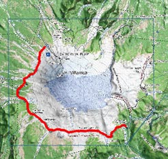
Area Map
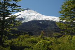
View to Villarrica volcano with the Challupén glacier on
the southwestern slope
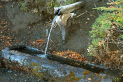
Water fountain in Zanjón Pino Huacho
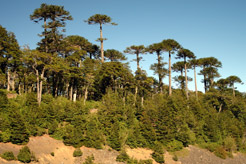
Araucaria forest on the edge of a ravine
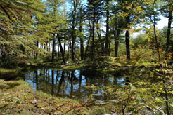
One of the "Laguitos de Challupén" ponds
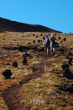
Marked trail through the high land grass
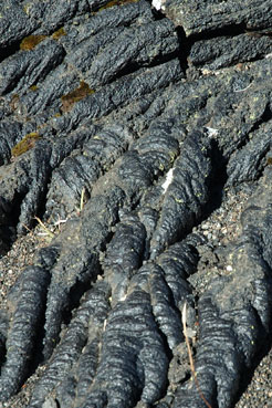
"Corded lava" in the "Valle del Fuego"
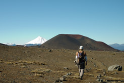
Walking towards Lanín volcano and a secondary crater
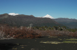
In the Champulli area with views to Quetrupillán and Lanín
|


