|
|
| Laguna
Huesquefilo – Villarrica National Reserve |
|
| It
is a short walk to this remote small lake in the Andes, surrounded
by araucarias. It offers wonderful views to the snowy summit
of the Sollipulli. However, since it is a long drive from Pucón,
it is better to combine it in a circuit with other excursions,
instead of planning it as a day trip. |
|
 |
| General
Information: |
| |
Distance
and duration:
Until
the beach in the south shore of the Laguna Huesquefilo there
are 14,2 km roundtrip, 1¾ to 2½ hours uphill,
1½ to 2 hours back. Starting point at 990 meters, maximum
height 1.320 meters, total ascent 380 meters.
From Reigolil there are extra 11 kms until the start of the
excursion, mostly flat. In time there are about 2 to 3 hours,
depending on how much weight are you carrying around.
Physical
demand:
Low.
Orientation:
Easy. There are no signs to the start of the trail, but once
you are there, it is very easy to follow.
Best
time to do it:
December to May.
Equipment:
We recommend trekking boots; with dry weather good sport shoes
are fine.
Entrance
fee:
There
is none. |
| |
 |
| How
to get there: |
From
Pucón, take the good paved road to Curarrehue until
km 37. After this town there is a turn to the left with the
sign Reigolil. You have to cross the bridge over the Trancura
River and immediately afterwards turn again to the left. Now
you drive through a good gravel road. At km 38 we reach another
bifurcation and you have to take again the road to the left.
At km 46 we cross a bridge over the Maichín River,
which runs in a tight bed. Always driving through the main
road of the valley, at km 49 there is the impressive catwalk
“Basas Grande” which is well worth a visit. The
road continues through the valley along several hamlets and
the small villages of Quiñenahuín (km 65) and
then Reigolil (km 79). Until this point there is public transportation
once a day. If you are not driving your car, you can cross
using the catwalk and continue through a dirt road upriver,
always along the main valley, until reaching the entrance
to the reservation.
From Reigolil the gravel road continues along the valley which
gets wider now and it is possible to see the Nevados de Sollipulli
at the bottom. The Nevados is a chain of summits, which actually
is the border of a huge crater 3 to 5 kms wide. At km 83 you
have to turn to the right and take the road that crosses the
Sollipulli River and continues to the north. We come back
getting closer to the main river. At km 86 we reach another
bifurcation to the right, we cross the Reigolil River and
immediately afterwards we turn to the left to get more into
the valley. Now the road gets difficult to follow and, if
you are not driving a high clearance vehicle, it is better
to continue on foot. At km 90 there is a welcoming sign to
the National Reservation. After another kilometer we reach
a gate and the path gets so bad that it is better to park
here.
|
| |
 |
| Route
description: |
The
valley gets narrower and the trail gets closer to the mountain
slopes. You can hear the torrent of the River Reigolil or
Curinemo further below, but you scarcely see it through the
foliage. This first part passes through a well worked countryside,
crossing gates and fences limit the trail. After walking for
about 20 minutes, you have to take the path to the right which
is well marked with a big CONAF sign. Through the trail that
continues to the north it is possible to get to Melipeuco
in a long walk.
The trail starts to climb the mountain slopes. There are parts
with open prairies and others under shadowy forests. There
are parts where the trail seems to split, but many times it
gets back together. In case of doubt, it is better to always
take the one to the left. Walking for another 30 minutes from
the beginning of the ascent we reach a plateau, a prairie
with araucarias, coigües and bamboo. It is clear that
this zone was once exploited; the slopes show remains of old
timber fires provoked by the pioneers. To your back there
is the southeast slope of the Nevados de Sollipulli with a
chain of prominent summits, waterfalls made by the thawing
ice that precipitate to the valley.
After walking for another half an hour we reach the shore
of the Lagoon Huesquefilo, a water body about 1.000 meters
long and 300 meters wide, at a height of 1.295 meters above
see level. The shadow of a group of araucarias invite to a
picnic.
On the opposite shore you can recognize a sandy beach. To
get there you have to follow a path that gets to right (south)
and continues along the shore. Several small rivers flood
the path and make it difficult to follow, but after 30 minutes
a detour to the left will take you to the beach. Other paths
continue to the border landmark with Argentina, which is nearby.
From the beach there is a beautiful view to the Lagoon Huesquefilo
with the Nevados de Sollipulli at the bottom. Only to get
this view, the entire excursion is well worth. Officially
it not allowed to camp here, but remains of many bonfires
indicate that this prohibition is not quite followed.
The way back is using the same path. |
|
 |
| Support
for this hike: |
Guide:
You can hire an English or German speaking guide for this
excursion for Ch$ 80.000 (US$ 100).
Transfers:
If you don't have your own transport, we can organize the
transfer for you (please ask at least with one day in advance).
These are the different options, all rates for the ride with
up to 4 people:
| Transfer
to the trailhead |
Ch$
70.000 |
| Dropping
off and picking up (on the same day): |
Ch$
100.000 |
| Transfers
both ways, including bilingual guide on the hike: |
Ch$
140.000 |
|
For
larger groups over 4 people, please ask for rates.
Note: The rates do not include possible entrance
fees.
GPS Rental:
We can also rent you a GPS device with the uploaded track
and waypoints you will need.
For detailled information>  |
|
|
|
|
Click
here
to see enlarged images
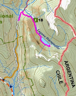
Area map
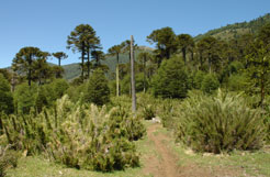
Path among bamboo and araucarias
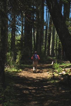
In the shadow of araucarias
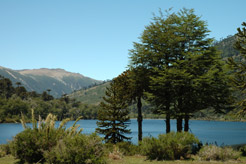
First meeting with the Huesquefilo lagoon
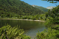
Sandy beach on the southeastern shore

Huesquefilo lagoon with the Nevados de Sollipulli in the background
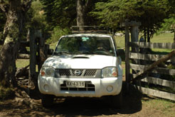
The access is not easy
|
|


