|
|
| Hike
in the Turbio and Correntoso valleys – Villarrica
National Park |
|
Interesting
excursion that allows you to know areas which were affected
by ancient lahares (volcanic flows) and lava flows which created
many waterfalls. It offers spectacular views to the Villarrica
volcano and an impressive contrast between barren dumps and
thick forests. Even though the area is close to Pucón,
and even some parts are inside the Villarrica National Park,
it is not a very visited place.
The excursion combines the valleys of Turbio and Correntoso
through the La Montura pass, which is due to the orientation
and physical demand the most difficult; but there are a number
of other possibilities for an easy family half-day-excursion,
or you can choose an even more demanding one. |
| |
 |
| General
Information: |
| |
Distance
and duration:
It
depends on the starting point. From the fork mentioned in
the description there are about 18 kms or 4½-5 hours.
If the gate after the Correntoso Bridge is closed, you have
to add 5 kms and an extra hour to the walk.
If you want to make the CONAF Río Turbio circuit (without
crossing the Montura) there are 9,3 kms from the Pichi Turbio
or 2½-3 hours walking. However, if the gate after the
Correntoso Bridge is closed, you have to add 11 kms and 2½
hours walk.
Altitudes:
Río Correntoso Bridge: 420 meters
Fork Pichi Turbio/Pedregoso: 550 meters
Waterfalls Pichi Turbio: 680 meters
Highest point of the CONAF circuit: 980 meters
La Montura Pass: 1,080 meters
Physical
demand:
Low, except the part of the ascent to the La Montura Pass;
if the gate of the Correntoso Bridge is closed, the distances
are bigger and the physical demand rises to medium.
Orientation:
Easy (except the La Montura Pass, where it is really difficult).
There are signs at the entrance, and the CONAF circuit is
marked with numbered iron stakes. Since the trail is scarcely
visited, there are some parts in the dump where it is hard
to follow.
Best
time to do it:
November to May.
Equipment:
Best
are good trekking shoes. It is also possible with resistant
sport sneakers.
Entrance
fee:
There is a charge of $ 3.000 per person. |
| |
 |
| How
to get there: |
Getting
out of Pucón, take the paved road to Argentina (Camino
Internacional) until km 7 where there is a road to the south
with the sign “El Cerduo”. The dirt road goes
to the slopes of the hills and gets closer to the valley of
the river Correntoso, an outlet of the river Turbio. At km
10 you must ignore a fork with the sign “Kawellu-Co”,
and soon after that you will get to a bridge over a river.
Usually the gate on the other side is locked, but it is possible
to continue on foot or riding a bike. If it is open, you can
drive to the other side. When the road gets into the forest,
starts a tough ascent that can only be done with a 4 x 4 vehicle;
there is a place where you can leave your car just before
this part. If you can take the first ascent, then you can
continue until a fork about 2 km ahead, where wooden signs
indicate “Cascadas del Turbio” to the left and
“Pedregoso” to the right. If you want to do the
whole hike through the Montura Pass, it is better to the take
the car to this area, since you are going to come back through
the road on your right. If you just want to walk the circuit
“Cascadas del Turbio” you can continue until a
parking place next to the Pichi Turbio 3 km ahead.
From Pucón there are about 20 minutes until the bridge
Correntoso (km 11), about 30 until the fork Turbio/Pedregoso
(km 13) and 45 minutes to the Pichi Turbio (km 16).
|
| |
 |
| Route
description: |
At
the fork “Cascadas del Turbio/Pedregoso” you must
take the road to your left. 5 minutes after that you will
cross a ravine which is usually dry, before you get closer
to some isolated hills that you must get around to the left.
Twice you will have to open and close a gate. Wooden signs
“Cascadas del Turbio” show the route, which gently
ascents. There are only three houses in this valley, and sometimes
they charge $ 500 entrance fee to visit the waterfalls, the
ones you will reach after a 30 to 40 minute-walk.
The brook that is formed by the waterfalls is called Pichi
Turbio. It is possible to go on in order to get better views
of the waterfalls. It is very interesting to see the different
layers of eroded lava.
The route crosses the brook Pichi Turbio, and a fence on the
other side indicates that we are entering now the National
Park. After 5 minutes walking the path gets to a plateau with
volcanic dump, which makes it very difficult to follow. There
are some rocks stacked one on top of another that show the
trail. The basic route is to continue towards a small forest
to the right (south). Out of the volcanic dump the road gets
clearer and soon you will find another path. There is an iron
stake with the number 21: we have reached CONAF’s trail
Río Turbio.
Now there are two possible routes: the shortest but less interesting
is to take the path to the right until reaching the stake
16. More attractive is to follow the circuit to the left.
After walking 15 minutes through a path, you cross a lush
forest and get to the wide ravine of the Turbio
river. In case of a volcanic eruption, when the ashes and
hot lava melt the snow in a beat, huge mud slides originate
in this area, destroying everything in their way.
At stake 24 you get out of the forest and find another path,
few meters ahead is stake number 5 and an arrow indicates
to enter the forest upriver. The explanation to this “strange
numbering” is that the official entrance to this path
is 15 minutes on the other side of the Turbio
river.
Nevertheless, a private person prohibited the entrance and
closed the access. Getting out of the park there is an abandoned
steam machine in pretty good shape, that was once used to
work a mobile sawmill.
Back to stake n° 5, the path continues uphill along the
ditch of river Turbio. Sometimes it gets off the main route
to cross some creeks that only carry water after heavy rain,
sometime it gets closer to the main water course or passes
through small isolated forests that survived to mud slides.
The ground changes between solid lava that formed creases
after cooling and sand fields or fine pumice stone only a
few millimeters deep. The only vegetation is little invasive
specimens that learned to survive under these extreme conditions.
After 25 minutes walking from stake n° 5 we reach a viewpoint
to the first big waterfall of el Turbio, which falls between
rocks and large lava pieces that have been dragged to this
place. 10 minutes ahead there is another viewpoint to a second
waterfall, much higher than the first one. The landscape turns
drier, and the views to the Villarrica volcano get more and
more spectacular.
At stake n° 14 the path turns to the right. It is possible
to follow the riverbed of el Turbio, which is unmarked, to
get to other three waterfalls and finally reach the glacier
Turbio, covered with volcanic ashes, after a 2 to 3 hours
walk.
From stake n° 14 the path continues to the Pichi Turbio
which runs at the bottom of the hills you can see in the background,
which separates the valley of the Correntoso. It is clearly
to see a pass that due to its form is called the “Paso
la Montura” (Saddle Pass).
If you prefer to come back to the waterfalls of the Pichi
Turbio, you can continue this path to the north, downriver,
until reaching after about 40 minutes the stake n° 21
and same path you first took. The hike goes through a forest
along an ancient timber road, no longer in use.
To cross the “Paso La Montura” you must take a
detour from the CONAF’s path after stake n° 16.
A small creek makes it easier to cross the riverbed of the
Pichi Turbio. On the other side you have to get off the riverbed
and continue upriver about 500 meters and look for a path
that runs parallel, which is hard to recognize. It becomes
more notorious when you enter the forest –still climbing
parallel next to the river-, and about 100 meters afterwards
there is a detour hardly visible to the right, which you must
take. This path gets 50 meters closer to the mountain slopes,
and you clearly will notice when it starts to climb. If you
don’t find it, follow the slope through the forest,
without climbing the hill until you’ll finally reach
it. Due to the roughness of the hill, the rocks, and the vegetation,
there is no other way to cross through.
If you find the path, take it for about 10 minutes an then
you will see another path that comes from the pass, which
you will soon reach. A much eroded road goes downhill to the
wide valley of the river Correntoso, which is more barren
than the Turbio. Once reaching the bottom of the valley you
have to follow the road downhill that goes through the right
around an isolated hill which is in front, and after 75 minutes
you will get to the fork from where you started.
|
|
|
 |
| Support
for this hike: |
GPS Rental:
We can also rent you a GPS device with the uploaded track
and waypoints you will need.
For detailled information> 
|
|
|
|
Click
here
to see enlarged images
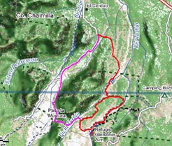
Area map
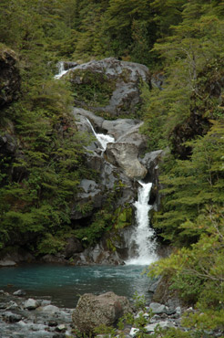
Cascades of the Pichi-Turbio
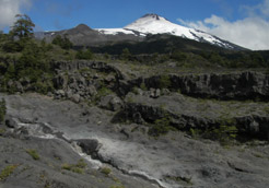
The lava flows have formed the landscape
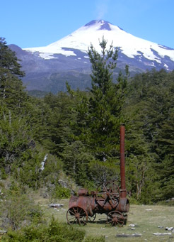
An old steam machine, relict of the timber activities
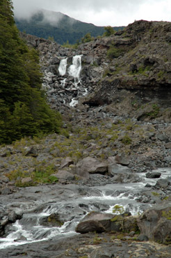
The Turbio river flowing through the lava fields
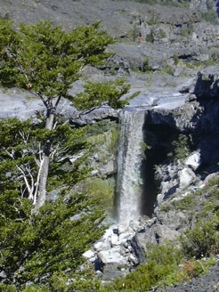
One of the waterfalls formed by the Turbio river
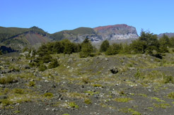
View to Cerro Patrón, wall of an ancient volcanic caldera
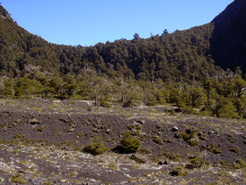
The "La Montura" pass, with its shape of a saddle
|


