|
|
| Ascent
to the Quetrupillán volcano – Villarrica
National Park |
|
| The
Quetrupillán, 2.382 meters high, lies just between the
two well-known volcanoes Villarrica and Lanín. It is
a good alternative for hikers who want to get off-the –beaten-track,
and stay away of the crowds that daily climb the Villarrica.
The view is spectacular as well, but it is not an active volcano.
Many people consider this ascent more scenic, since a good part
of the hike goes through lush native forest. Until the beginning
of the summer there are still some snow fields, but there are
no glaciers to be aware of. |
| |
 |
| General
Information: |
| |
Distance
and duration:
8 km one way, 3½ - 4 hours uphill, 2 - 3 hours back.
Staring point at 1.040 m, summit 2.380 meters, total ascent
1.430 meters.
Physical
demand:
Moderate, save the last 300 meters covered with volcanic stones
that difficult the walk.
Orientation:
Medium difficulty, inside the forest the path is easy to recognize,
but there are detours without signs. Watch out with the fog,
during the descent, it may be hard to find the orientation,
bringing a GPS along is recommended.
Best
time to do it:
January to May. There are extense snowfields untill beginning
of summer. Ir you know the route, it is possible to do it
in winter on randonée or snow shoes.
Equipment:
Good
trekking boots are a must, and hiking poles are also recommended.
In springtime or cold days crampons might be useful as well.
During the winter it is possible to climb with snow shoes.
Entrance
fee:
Announcement of the owners of the land bordering the National
Park:
WE INFORM THAT
THE TRAIL IS ON PRIVATE LAND BELONGING TO A SOCIETY CALLED
"CAMPO LA MONTAÑA" AND ACCESS IS RESTRICTED.
YOU MUST GIVE NOTICE THE ASCENSION TO THE VOLCANO WITH 24
HOURS ANTICIPATION. THE ACCESS FEE IS $5.000.-. THE NOTIFICATION
MUST BE DONE TO THE MOBILE PHONE +56 9 9978 6153 AND TO THE
E-MAILS cuo@holdingfrontera.com AND luisfelipediaz21@hotmail.com
. THE PAYMENT CAN BE DONE BY DEPOSIT OR FUND TRANSFER TO THE
ACCOUNT N° 65-66275-2 AT BANCO SANTANDER, ON THE NAME
OF "ASESORIAS E INVERSIONES LITO S.A." RUT 76.147.759-5.
ONCE THE PAYMENT IS INFORMED, WE WILL SENT YOU BY E-MAIL A
DOCUMENT OF CIVIL LIABILITY RELEASE THAT MUST BE SIGNED AND
HANDED OVER AT THE BEGINNING OF THE ASCENTION. THOSE WHO DO
NOT FULFILL THIS REQUIREMENT AND ARE NOT REGISTERED, WILL
BE NOT ALLOWED TO ENTER THE TRAIL.
To see the full comunication (Spanish only) > 
If you leave the car in Fundo Porvenir, the Ulloa family may
also charge you a fee. |
| |
 |
| How
to get there: |
Getting
out of Pucón take the paved road to Argentina (Camino
Internacional) until the Crossing Palguín (km 20),
turn south and continue to the Termas de Palguín
through a good gravel road. Instead of entering the hot
springs (km 30) take the road to the left with the sign
“Coñaripe” until an entrance marked “Paraíso
Escondido” (km 33). Soon you will reach a gate of
this private estate that is usually not locked. Tou have
to cross two bridges, first the Cinay creek and then Palguín,
with a small pond on the right. There are several forks,
take alway the left one, except if you see it leads you
down to the river. There are some small signs "Volcan".
finally you get to the gate of the Fundo Porvenir (km 38).
200 meters ahead you get to the house of the Ulloa-Argüello
family.
If the road conditions and your car allow it, you can continue
the road to the left, cross a small wooden bridge over the
Mocho creek and climp the slope on the other side. After
a flatter
part, before entering the forest, the track ends and continue
as a foot path. Leave your car here, withoud blocking the
route.
From Pucón there are 38 kilometers in all and takes
about 60 to 75 minutes to get there. Inside the estate Paraíso
Escondido the road is tougher, but normally good enough
for any kind of vehicle. There is public transportation
until the crossing Palguín (km20), and there is a
good chance for hitch-hikers to get to the Termas de Palguín
(km30).
|
| |
 |
| Route
description: |
Immediately
after the house there is a fork with signs: ahead you will
find the alternative entrance to the trekking known as the
“Villarrica Traverse” through the Estero Mocho,
arriving after a six-hour-walk to the Laguna Azul. To climb
the Quetrupillán, which you already can see far away,
you must cross the bridge over the Mocho creek. The trails
climps the slope and the continues during the first half an
hour through a flat land which still shows remains of the
fires the pioneers made to get through the thick forest. From
the path there are several ancient roads, but you must follow
the clearest one. Finally we enter a forest with evergreen
coigües; the path gets narrower and steeper. After 70
minutes walking there is a path to the left, it gets down
to a small creek and crosses it, but the right path continues
straight ahead. There are some arrows carved in the trees
that show the right way.
Gaining more and more altitude, the coigües are replaced
by lengas covered with lichen. After walking another 20 minutes,
the trees grow smaller and smaller, until the 1.600 meters
high where we finally reach the limit of the forest and find
an Andean prairie.
At last we can see our goal, but there are still 90 to 120
minutes to walk. It is possible to distinguish two summits,
the higher one to the right. The path descends a little and
gets closer to a creek that follows in small waterfalls from
the slopes of the Quetrupillán. Important: It is the
only chance to get safe water. There is a path that goes to
the right and crosses the creek, continuing to the south to
the Laguna Azul.
The path uphill continues left of the creek. Due to the rocks,
sometimes it is hard to follow the road, but it continues
very straight up to the top. While we are getting higher and
higher, we have more impressive views towards the volcanoes
Llaima and Sollipulli to the north, the Villarrica to the
west and the Mocho/Choshuenco to the south. The last 300 meters
are exhausting, the path is very steep with a lot of loose
volcanic stones, which difficult the walk. Once on the top
you have a view to the east to the Lanín Volcano, 3,747
meters high, making it the highest of the region, and the
impressive mountains Peineta and Colmillo del Diablo (Devil’s
Fang). From the highest summit, the one to the south, it is
possible to see the Laguna Blanca below.
The summit of the Quetrupillán is the eroded edge of
a crater, which is several kilometers wide and falls to the
west. The last eruption was on 1872. Inside of the crater
there is a glacier which waters fall to the valley of Rinconada.
|
|
 |
| Support
for this hike: |
|
Transfers:
If you don't have your own transport, we can organize the
transfer for you (please ask at least with one day in advance).
These are the different options, all rates for the ride with
up to 4 people:
| Transfer
to the trailhead |
Ch$
50.000 |
| Dropping
off and picking up (on the same day): |
Ch$
80.000 |
|
For
larger groups over 4 people, please ask for rates.
Note: The rates do not include possible entrance
fees.
GPS Rental:
We can also rent you a GPS device with the uploaded track
and waypoints you will need.
For detailled information> 
|
|
|
|
Click
here
to see enlarged images
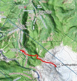
Area map
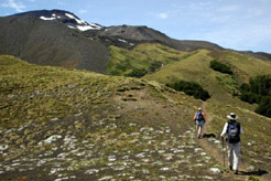
Leaving the forest behind, finally the goal gets in sight
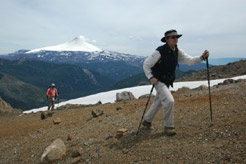
Approaching to the top, with Villarrica volcano behind
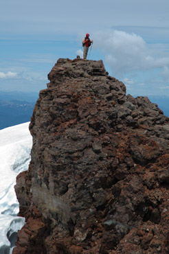
The highest point of the Quetrupillán is this peak, on the
edge of the crater
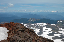
View to the south, with the Mocho-Choshuenco volcano
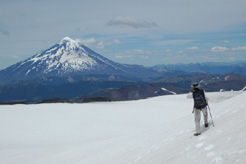
The crater is filled with ice, Lanín volcano in the background
|
|


