|
|
| "Quinchol"
and "San Sebastián" Trails – Huerquehue
National Park |
|
In
the Huerquehue National Park there are other less visited trails
than the Los Lagos one. For example, to the Cerro Quinchol,
which lays east of the Lake Tinquilco. From the top there is
a wonderful view towards different volcanoes and mountains.
Being the view its main attraction, you might consider if it
is worth doing this trail on a cloudy day.
From the Cerro Quinchol there is also the chance of extending
the excursion through the trail San Sebastián to reach
the top of the name’s sake mountain, which with almost
2000 meters is one of the highest in the park. There is no need
of climbing experience, but there are areas where you must watch
your step and walk carefully. Due to some steep cliffs it is
not recommended for people who suffer vertigo. The upper part
is open to the winds, and can be very dangerous. |
| |
 |
| General
Information: |
| |
Distance
and duration:
Quinchol
Circuit: 8 km round trip, 1½-2 hours uphill, 1-1½
hours back. Starting point at 780 meters, maximum height 1.420
meters, total ascent 740 meters.
Ascent to the Cerro San Sebastián: 13,8 km round way,
14,6 km if you take the Quinchol Circuit back; 2½-4
hours uphill, 2-3 hours back. Starting point at 780 meters,
maximum height 1.920 meters, total ascent 1.250 meters.
Physical
demand:
Trail
Quinchol: low.
Trail San Sebastián: moderate.
Orientation:
Easy,
the trails are well marked, there are signs and stakes. Parts
of the ascent of the San Sebastián are less clear,
but since you have to aim to the top, the trail is pretty
obvious.
Best
time to do it:
Trail
Quinchol: November to May.
Trail San Sebastián: January to April.
Conaf does not permit the ascent in winter with snow.
Equipment:
Since the trail is very steep, we recommend trekking boots
and hiking poles. For the trail Quinchol it is OK with good
sport shoes. It is important to bring along enough water.
Entrance
fee:
Tickets must be bought before at www.pasesparques.cl and shown at the CONAF
ranger station. |
| |
 |
| How
to get there: |
From
Pucón, take the road to Caburgua until km 20. There
you have to turn right, there is a sign to Huerquehue National
Park, and you have to continue through a gravel road that
gets to the hamlet of Paillaco at km 27. From here the road
continues uphill to reach at km 32 the Tinquilco Lake and
at km 34 the entrance to the park where is the rangers’
control office and visitor’s center of CONAF.
The road continues in regular condition (not recommended for
low vehicles) for about two kilometers until the end of the
lake, where there is a parking lot that charges for the spot.
There is public transportation (Buses JAC) until CONAF. Along
the shores of the Tinquilco Lake there are several simple
campsites, a couple of bed & breakfast, and two nice hostels.
It is possible to get bread, eggs and some basic groceries,
but it is better to bring what you need from Pucón.
|
| |
 |
| Route
description: |
The
beginning of the trail is about 400 meters after the control
booth, there is a sign “Sendero Quinchol” to the
right. After 10 minutes climbing, you hear to the left the
gurgle of a brook. Warning: this is the last chance to get
water. The trail now continues in zigzag through the slope.
It is possible to have some views to the Tinquilco Lake and
the waterfalls and the bottom of the valley through the vegetation.
After walking for 40 to 60 minutes, the vegetation gets wilder,
with big coigües and the first araucarias. 15 minutes
later there is a fork: there is an arrow to the left that
indicates “Sendero San Sebastián” and another
one indicating to both ways “Circuito Quinchol”.
We suggest taking the one to the left, since later is easier
to find the right way.
After some minutes you get out of the forest and reach a mountain
pass with coirón, a characteristic highland grass that
grows in small hillocks and makes it difficult to walk. There
are many isolated araucarias of different heights and sizes.
The trail gets difficult to follow, but it is marked with
iron red stakes. Further ahead you can see a wooden sign indicating
“Sendero San Sebastián” straight ahead
and “Circuito Quinchol” to the right. From here
you have an impressive view to the mountains San Sebastián
and Nevados de Caburgua with the Llaima volcano to the north
and to the volcanoes Villarrica, Choshuenco, Quetrupillán,
Quinquilil (Devil’s Fang) and Lanín, the later
with over 3700 meters, the highest one.
Even though you don’t intend to go to the San Sebastián,
it is worth to walk for another 10 minutes in that direction
in order to reach a view point to the lakes Tinquilco and
Caburgua before the trail gets downhill and back to the forest.
Circuito
Quinchol:
From the sign mentioned above, the trail to the Circuit Quinchol
turns to the south and then gets into a beautiful forest with
araucarias and lengas next to a small hill. Here there are
some brooks from which you can take water, but only in case
of emergency, since it is not clear if it is safe or not.
30 minutes later you get out of the forest and reach another
pass covered with coirón. From the sign mentioned above,
the trail to the Circuit Quinchol turns to the south and then
gets into a beautiful forest with araucarias and lengas next
to a small hill. Here there are some brooks from which you
can take water, but only in case of emergency, since it is
not clear if it is safe or not. 30 minutes later you get out
of the forest and reach another pass covered with coirón.
|
To
the southwest you see a hill that you can reach in about
10 minutes walking through bushes, always aiming to the
top. Sometimes there seems to be parts of a trail, but they
get lost after a while. Over some rocks there is a viewpoint
with the most impressive view towards the valley of the
Trancura River with a chain of volcanoes at the bottom.
There are about 1000 meters extra roundtrip, with an ascent
of 70 m
|
From
the pass, the trail turns to the north and starts to get downhill
towards the Tinquilco Lake. In about 10 minutes you finish
the circuit getting to the bifurcation, and in another hour
you will be again at the CONAF’s control, where you
started the excursion.
San
Sebastián Trail:
From the plateau where both trails separate you have to take
to the northeast, towards the Cerro San Sebastián that
you can already see. Shortly afterwards you will reach a viewpoint
that opens to the north. You can clearly see the intermediate
depression where the lakes Chico, Verde and Toro lay, but
you can’t see the lakes yet. At the bottom you will
distinguish the Llaima volcano. Then the trail gets downhill
a little bit and enters again the forest. The trail continues
through the crest of the mountains that are part of the Nevados
de Caburga. There are plainer parts that take turns with more
steep ones. Bamboo stakes painted in red confirm that you
are on the right trail. Soon afterwards the big coigües
disappear and are replaced by lengas. Each time that the trail
gets closer to a cliff to your right, you find wonderful views
towards the valley of the Nevado River, which runs hundreds
of meters below.
45 to 60 minutes from the bifurcation the forest gets less
thick. The araucarias grow smaller and the soil gets rockier,
and finally the lenga is the only tree that survives at this
altitude, but only with small specimens, known as “krummholz”.
The trail gets heavier, with very steep parts, and you even
have to crawl using lenga roots, trunks and branches. After
some very difficult parts rocky hillocks appear over the crests
that show even more impressive views while you are getting
higher and higher. Near the 1700 meters even the lenga disappears.
Only coirón, some bushes and few other plants can adapt
to this highland climate.
15 minutes later you think that you have done it. But once
you get to the top, you realize that there is still some way
to go, to another higher top ahead. To both sides the mountain
falls hundreds of meters; buy usually there is a safe path
to the top. Only when rocks get in the way you have to be
very careful and look for the best way to continue.
10 minutes later is the same story all over, but now you see
the right summit only 200 meters ahead, marked with a bamboo
stake. Now you are at 1920 meters high. The view is just spectacular
to the volcanoes Llaima, Tolhuaca, Lonquimay and the Sierra
Nevada to the far north; the Lanín, Quetrupillán,
Mocho, Choshuenco and Villarrica to the south. Almost like
a bird you can see from above the lakes Chico, Toro, Verde,
and the lagoons Huerquehue, Escondida and Seca. Also to the
south you can see the Lagoon San Manuel, which lies to the
bottom of the Cerro San Sebastián. |
|
|
 |
| Support
for this hike: |
Guide:
You can hire an English or German speaking guide for this
excursion for Ch$ 80.000 (US$ 100).
Transfers:
If you don't have your own transport, we can organize the
transfer for you (please ask at least with one day in advance).
These are the different options, all rates for the ride with
up to 4 people:
| Transfer
to the trailhead |
Ch$
40.000 |
| Dropping
off and picking up (on the same day): |
Ch$ 70.000 |
| Transfers
both ways, including bilingual guide on the hike: |
Ch$
120.000 |
|
For
larger groups over 4 people, please ask for rates.
Note: The rates do not include possible entrance
fees.
GPS Rental:
We can also rent you a GPS device with the uploaded track
and waypoints you will need.
For detailled information> 
|
|
|
|
Click
here
to see enlarged images
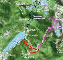
Area map
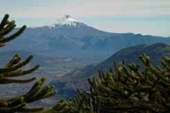
Villarrica volcano from the Quinchol lookout
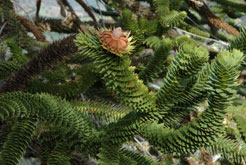
"Piñones" are the fruits of the araucaria trees
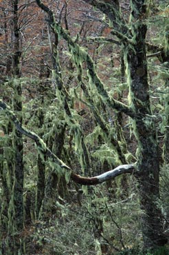
Lenga forest with hanging lichen
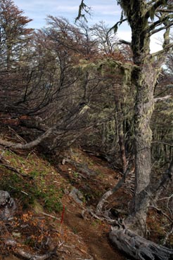
Path through thr lenga krummholz
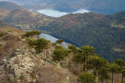
Tinquilco and Caburgua lakes
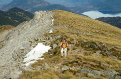
The last few steps to reach the summit of San Sebastián
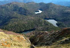
From the summit you can see the lakes Chico, Verde y Toro ("Los
Lagos" Trail), ans the Escondida lagoon in the foreground
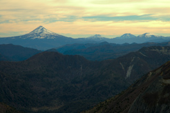
View to the north with the volcanoes Llaima, Tolhuaca, Lonquimay
and Sierra Nevada
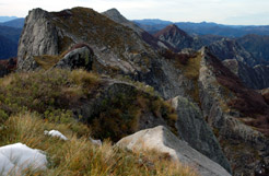
Other peaks of the Nevados de Caburgua
|


